
AUSTRALIAN ULTRA RUNNERS ASSOCIATION - FOSTERING AND PROMOTING THE SPORT OF ULTRA RUNNING.
MEMBERS
A LONG WAY TO A ROCKY ENDING
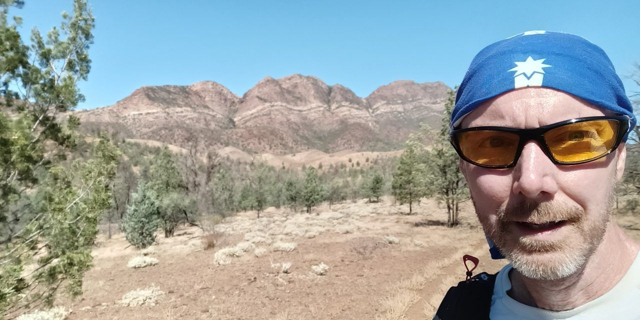
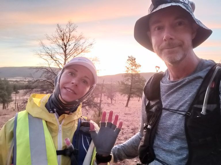
Contributed by Doug Bartlett, AURA member (Willetton, WA)
2023 IRRATIONAL SOUTH, FLINDERS RANGES (SA), 12-16 April 2023
I woke from my sleep with a start: it felt like something was crawling on me. Yes, there was something on my face! I plucked a large thing off me and in my head light I could see it was an enormous moth. Another one was crawling around on the beanie on my head. I threw them away, then regretted moving as cold water trickled down past the emergency blanket and another gap opened up to the wind, exposing my wet back. I shivered violently, while Sarah laying beside me mumbled something. I had lost track of time and looked at my watch.
How long had we been lying there in the sheltered spot, trying to keep warm, avoiding the wild wind and rain?
“Sarah, I think we need to activate your SOS, are you ok with that?” I asked. I knew at some point when hypothermia kicked in I wouldn’t be able to make smart decisions, and wanted to make this one before then. I figured as I was still shivering on and off, I was still above the threshold. It was our third night into the race with only around three hours’ total sleep, so who knows if my thought processes even made sense?
She agreed, and so I triggered her SOS. Then I tried to doze off again and not shiver too much.
RACE DAY
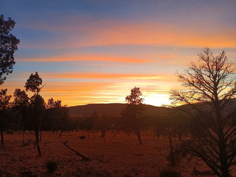
The morning of race day was chilly and windy, as us 50 or so crazy runners, crew and event staff listened to Christian from Wadna shop welcome us to Country. He told us about the area we were running through and the significance to his people. In no time at all it was seven a.m., the countdown was done and we ran off down the gravel road. It was an easy start along the gravel and then sealed roads, doing a short loop around a hill to come back through Blinman where a number of crew and volunteers cheered us on. The easy undulating gravel road led on and in no time I was at the Parachilna Gorge entry to the Heysen Trail, 40km in as the sun warmed us up.
I’d had a short reconnaissance run with Sarah yesterday up the track, so ran confidently up the loose gravel creek bed that formed the trail for the next 10 or so kilometres. A little while later, following the slope of a ridge, I’d lost the trail markers and decided the right way to go was through that gap where the goats had gone, down another creek line. On and on I went, luxuriating in this beautiful gorge that kept getting narrower and narrower. Hmm, I wonder if I’m on course? No, I was nowhere near it, and all around me were ridges and ranges that gave no hint of where the trail was. My GPS signal was telling me porkies, almost as if the magnetostratigraphy of the area was deliberately trying to lead me into the endless gorge. It was a moment right out of Picnic at Hanging Rock.

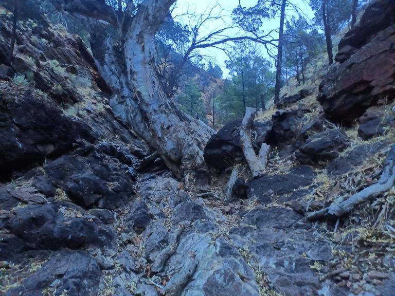
The only choice was to backtrack until I spotted some other runners, having lost around 40 minutes. From then on I was more cautious, and eventually reached Aroona aid station at 2:38pm, after 58.2km (plus about 4 bonus kilometres). As I came in, Sophie the photographer snapped a beaut backdrop of two emus behind me. Here we encountered our first introduction to one of the fun parts of the race: swathes of short plants with large sticky and spikey seed heads that stuck to everything. Our shoes, socks and calf covers looked like they were decorated with pom poms made of seed heads.
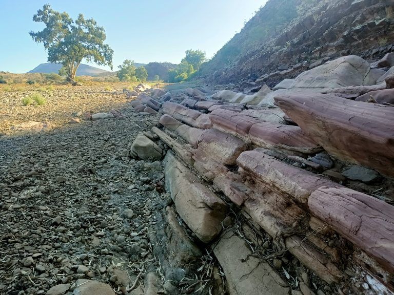
I didn’t spend much time there, ready to keep moving on to Trezona aid station. Every now and then a massive gum tree reared up in the creek beds, monstrous roots anchoring these giants against the pressure of history. Ochre reds, pale greens, large masses and flints and flakes. Rocks of every shape and age ground away at our feet.
After an interminably long run and hike on the rocky creek beds I reached Trezona at 5:12pm with the sun setting, 72.5km in. As I settled down for a feed, Tonie arrived in a bundle of happiness. She must have been running up a different creek than the one I was in. She didn’t muck around and left just ahead of me. I soon passed one of my milestones, 80 km at 11hr15. This was a good time for me so things were going well as I turned on my headlamp for the first night leg.
The next aid station was Bunyeroo, which I reached at 7:08pm, 83.7km in. I decided to have just a brief sit down and a coffee, then followed the marker off into the dark between some conifer trees. The markers disappeared, and I wandered around for a while, trying to go in the direction on the gpx file. Following a promising goat track along a hill side, I saw a light up above me and called out. It was Tonie, also trying to find the trail. We joined forces to help navigate through the 24.5km section. At one point we stopped, turned our headlamps off and looked up at the stars, lost in the immensity of the milky way. The light that was reaching us was older than the rocks we stood on.
Near the end of the section I started moving faster as the trail was well marked and going downhill, leading me into Wilpena Pound aid station (108.2km) by midnight. I settled down to some warm soup as the temperature had dropped a bit, and sat quietly letting my head and body rest. God my feet hurt.
I was jolted into the present moment upon hearing one of the race directors on the phone “Sarah you’re going the wrong way around Mary’s peak. You need to come back and start the loop again.” Shit! She was about an hour ahead of me so that would mean another hour backtracking. I hadn’t even thought about the risk of going the wrong way around this loop. I sent her a text message to help, then finished my food and headed off to the sleep pod for my planned hour of sleep.
I didn’t get much sleep but Sarah called, confirming she was now going the right way around. A little later I was off myself to tackle the Wilpena Pound loop. I kept an eye out for the pink flagging, then saw my turn. It lead onto a beautiful single trail into the forest and darkness. The trail started ascending, getting rocky and rocky, until it was pure scramble over rock from the dawn of time. Both hands were needed to hoist up the rock as the trail ascended forever into the darkness. Somewhere up there was the Akurra’s head, the male serpent who with the female serpent according to the aboriginal creation story, caused the mountains and creeks to form from the writhing of their bodies. I would be crossing somewhere behind his neck, just a tiny flickering of light across a being that lay there from the dawn of humanity. And yet from the geologists’ reckoning, even the great serpents only existed for a few seconds of deep time.
The long descent on the far side was at a gentle gradient, but rough with large rocks requiring goat-like agility, and smashing my feet again. This snake needed a bit of exfoliation.
When I eventually arrived back at Wilpena Pound aid station, I found Sarah still there, having had a rest. So we headed off towards Quorn together. It was early morning and chilly again, so I started with my thermals on, then as the day soon warmed up I took them off. I could leave them at Mt Little that night where my next change of clothes was, and I thought I wouldn’t even need thermals that night.
Kangaroos eyed us from afar as we wandered across a wide grassy area with scattered trees, then ascended amongst some head-high bushes that hid the markers and tried to lead unwary runners down false trails. Jacqueline caught up with Sarah and I here, and we were given a beautiful view out from Bridle Gap.New Paragraph
After another section of hunting for invisible markers just shy of the Black Gap aid station, we reached it. At 139km in, it was around 8:30am and the day was going to be hot.
I headed out from Black Gap again accompanied by Sarah, a geologist. “There are a shitload of rocks from different geologic time frames are present in the Flinders ranges” she said, all enthusiastic. So we ended up off trail due to the geologist wanting to look at some sparkly rocks, then had to find our way back. The trail disappeared into another dry creek bed, and so we were treated to layers, strata, regolith and the warp and weft of epochs. I wondered if maybe the rocks were eating the trail markers.
Partway up a hill, on a thankfully softer dirt trail, I’d pulled away from Sarah and found the Red Range water drop. Then a little further on Sarah caught up with me and found she’d missed the water drop, so she backtracked. It was close to 30 degrees now, in the middle of the afternoon, so you wouldn’t want to try another 16km without water!
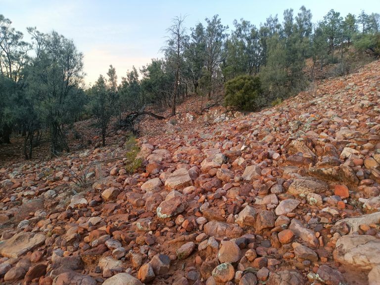
The trail soon rejoined a wide dry creek. And so it was: another 15km of rock hopping alternating with short sections of runnable loose gravel. My feet were getting bashed and battered, toes knocked and stubbed. Striations from the permean glaciation were putting their mark on the grey rock, and on us, in our feet and minds.
The sun was starting to set as I spotted the pink flagging tape. It led up to the right, away from the rocks. I soon found my way to Mount Little, a sleep station, at about 4pm and 171.5km in. Later I worked out that I’d passed the miler at 31 and a half hours into the race, a fairly normal 100 mile time for me, but slower than last year.
After the little out and back to the homestead where Shaun changed the GPS tracker batteries, I returned to Mount Little in the dark at 6:44pm and 180.5km. After a shower I was able to have a really good sleep for around 120 min, leaving at 9:55pm.
Soon after leaving I found Sarah and Ronnie, Jacquie and another runner all wandering around in the head-high bushes trying to find the trail. I had more luck, having found the trail earlier, and so we moved on following the South Australian marking system. Like the Lavender Trail from last year’s Irrational, the markers had an arrow on them that meant you should go roughly in that general, approximate direction. You either got it right, or you didn’t. Well, we soon made it through the bushes and back on the wide dry creek bed. And the creek bed was made of … rocks! We were done with geology by this point. These were just rocks: bloody hard, unforgiving rocks. Except for one lonely echidna.
An age later, I initially missed the marker leading out of the creek but managed to figure it out from the GPX file, coming out onto a dirt road and a gazebo with piles of water casks. It was the Old Wonoka water supply, which I’ve reached at 1:19am, having completed 195.5km. From here it is only 6.2km to Hawker, and now we’re running and walking along the shoulder of the highway with my hi-vis vest on. I thought “we” were on the highway, because every now and then I looked back and could see another light way behind me, but I wasn’t sure if it was another runner or not. In a little change of perspective, we could now run on relatively smooth hundred million year old gravel mixed with million year old squashed plants (i.e. bitumen). Maybe I wasn’t so old after all.
The moonlight shone down so I turned off my headlamp for a while, running along in the dark. Every now and then something rustled in the bushes and strange creatures formed out of the dark shadows. I was pretty sure that whatever they were, they’d be more afraid of my runner’s aroma than I was of them. Maybe.
I finally reached Hawker at 2:14am, 201 km into the race. A fantastic toastie pie sandwich, coffee and soup helped me drift off to a short sleep. This geology stuff was hard work. When I woke, I found that Sarah had again caught up and we left together at 3:40am. As we headed west into the darkness, the sky grew lighter and sprayed bands of red and orange over the clouds. Our geologist admired the “strata” in the clouds, and there was even cross banding, whatever that is. I took a photo because I liked the colours.
We were now treated to a nice surprise: the classic South Australian trail marker saying “Walkers Follow Fence”. And so we did, avoiding the dead sheep and goats that had been caught in the fences, time having stripped them into skin and bones. I’m surprised the geologist didn’t go a little nuts at this point: there were rocks bloody everywhere.
The rocks gave up to dirt after a while, and we found the Barnes Road water cache at 9:31am, 225km in. I was now 1hr and 20 minutes over my original race plan, so I was getting a sense that this race might take longer than I thought. The day was warming up again as we followed a long gravel road and then a clay-dirt road into Partacoona. The rock here was so old it had worn away to fine particles of dust in the heat. The heat rose, and time sapped our will, draining and extending.
Finally we reached the Partacoona Road Aid Station at 11:40am, 239.8km into the race. The finish was now less than 100km away. As we were having our lovely aid station snacks and drinks, a farmer dropped by and warned the volunteers that with the coming storm and rains they might get cut off. Near us was one of those large dry creek beds, and the road in crossed the creek bed.
It was still hot although cloud had started to gather across the sky as I followed the fence into another creek. ‘Oh well’, I thought ‘another creek to follow’. Gosh I love these creeks. Every 200 miler has something special to challenge its runners, and this one was undoubtedly the rocky dry creeks. Creeks with rocks in them.
I had one of those mistaken-thinking moments that only happens in this kind of race, after two nights and very little sleep: I didn’t think to check my GPX file. So it wasn’t until a few kilometres later that I did check my GPX and couldn’t make sense of why the little blue dot was nowhere near the trail. Then I saw Ronnie and Kath ahead of me. They were Sarah’s crew, driving on to the next aid station at a creek crossing. After a bit of a chat I figured out I was way off track, so ran back along the top of the ridge. Somehow the burst of adrenaline from being lost spurred me on, until I eventually found my way back to the trail and then crossed the creek at the right spot. I found out later that both Sarah and Jared had gone the right way and were now ahead of me.
Now we had some hill work, following a range of hills to the south, at one point dropping down across a creek over pure white clay. I wonder if that’s in the geology books?
Then there were more rocks, until the trail joined a dirt track leading into Buckaringa Gorge Aid Station which I reached at 4:20pm on the third day, and 256.1km in. It was warm and humid, with cloud covering the sky as I sat down next to Loki. He had a beaut spot in the seat next to me, happily covered by a blanket despite the warm air, with his long brown ears and sad eyes wishing for food. I was careful to keep my food out of his reach. Loki was the aid station family’s dog.
The sun was setting as I left Buckaringa, excited to be ticking away the kilometers, and confident that with the day so warm I wouldn’t need my thermals that night. Time had been warping strangely through the day, compressed by the ages of the rocks, blown like dust by the wind. All I had to do was keep moving, eating, and drinking. I again had this strange inner sensation, of having to move myself and my body to the finish. There was no other way of getting it there.
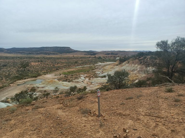
The gorge was stunning. Dark rock was etched into a channel only a few metres wide, with impressive trees thrusting their roots into the cracks. Some of the gorge required scrambling and climbing, as a light rain started falling. And then the gorge opened to a grassy hill, and there was Sarah coming towards me. She was having trouble finding the next marker, and so we joined up again to find our way over grassy hills as the rain and wind grew.
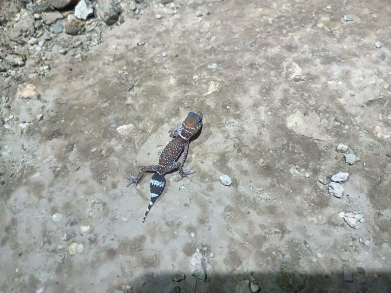
The trail opened out onto a four wheel drive track, and with Sarah’s GPS navigation we walked our way up and up and up. It was now dark and all we could see was the spiky low lying bushes around us, a track leading up into the darkness, and blackness all around. It was getting hard to talk, as the wind howled over the hill, blowing us around. The rain came and went, and the temperature started to drop as the trail also started to descend. Out there in the wind and rain, there was still a little bit of life around and I admired a pretty little lizard with a black stripey tail. He didn’t seem to mind the cold.
After a while we were back in another valley, a narrow creek with plants and narrow dirt track to follow. The temperature was still dropping and we were now soaked in our rain jackets and feeling the cold. We stopped briefly and tried to wrap some emergency blankets around Sarah because she was shivering and moaning about the cold. I was starting to wonder what had been in my head to not bring my thermals as I was starting to get cold too. The best solution for where we were was to run faster and try to get the next aid station, wherever that was.
A race marker turned us out of the narrow creek as the rain got heavier, and now streams of water were running down the four wheel drive track as we trudged up, hugging together to keep warm. Somewhere off this deviation was the aid station, but I didn’t know if it was up, down, left or right, or even how far it was. With the rain and cold it had become difficult to work my phone because the touch screens don’t work when they’re wet. So we headed up a new hill, followed a large red arrow which somehow felt wrong, and then tried to call the race director to get advice.
It turned out we’d been going in the wrong direction, but we were now very cold and I wasn’t sure we could both get to the aid station, especially if it was up more of these wind-beaten hills. So we found a slightly sheltered spot on the hillside and lay down to try and get warm.
BACK TO REALITY
Some time later, the moths had disappeared and I heard a voice. The rescue team had arrived. The original emergency ambulance had gotten stuck so two guys from one of the other runner’s crew had run all the way in from the aid station to find us. They brought a bunch of extra jackets and clothes and worked at getting Sarah warmed up. I was glad just to be sitting there in a warm jacket, mind dazed from the threat that had come so close to us, reminding myself of my mantra for 200 mile races “There’s no place I’d rather be.”
The guys carried Sarah up to Michelle’s car while I walked up. Out of the sheltered spot, the wind whipped at us, and my legs almost froze on the spot. The weather had gotten even worse while we were sheltering. Inside the warm car, Michelle showed off some amazing four wheel driving skills, driving like a lunatic (the good kind) up and down the tracks and out to the road where Sarah was whisked away in an ambulance for treatment for hypothermia.
The race had been cancelled sometime before we triggered the SOS, because people all along the course were getting into trouble. Eventually everyone was able to make it back to Quorn, even the ones temporarily stranded out at Eyre Depot and Partacoona. All the runners still on course were credited with finishes, and I was awarded third place male, with Sarah getting second female. We were within 50km of the finish.
Now I wonder: do I take the rocky path once again?
Photographs – Doug Bartlett.
share this
IN OTHER NEWS

FOSTERING AND PROMOTING THE SPORT OF ULTRA RUNNING.
Site by Fruitful Creative